Tunnel Creek and Windjana National Park. September 29, 2013.

Sunday, September 29th

We started our day with a coffee.  Very nice.

The unsealed road to Tunnel Creek was in excellent condition and we made good time to this
National Park.  The 750m long cave-like tunnel through the hill-side was wonderful.  It was very cool being hidden from the sun, but the extra bonus was wading in the creek.  Very refreshing.  At the halfway point bats were coming and going from the cave through a large opening.  They were making a racket while the sound of their leathery wings when flying was very impressive.

The Bat Cave.

Bat Sign.


Another hour along the King Leopold road and we arrived at Windjana National Park.  The rock structures here are similar to coral and used to be a reef some 350 million years ago, so yes under water.  Now they provide a home to freshwater crocodiles and numerous birdlife.  The blistering heat made the 2km round trip walk hard work, but seeing the crocodiles in those amazing surrounds was worth it.

Windjana Gorge.

Windjana Gorge is one of the best spots to see freshwater crocs up close.

We then headed west to Derby and the coast.  At last some relief from the heat with a very pleasant 34C.

Halls Creek and Fitzroy Crossing. September 27-28, 2013.

Friday, September 27th

There is not much to Hall's Creek.  But there was a bakery with latte coffee, and it was good and we were happy.  During coffee, Stephen noticed a sign offering the public a chance to see a weather balloon launch.  So, we "the public" made our way to the Bureau of Meteorology where we were welcomed with open arms.  Not sure that they get many tourists through the Hall's Creek office.  The officer on duty explained the various computers and instruments monitoring the weather and then launched the hydrogen balloon.  We were able to track it by radar.

Headed west in the direction of Fitzroy Crossing.  We made it halfway to Larrawa Homestead where we had exclusive use of the campground for the night.  The showers were good and boy did we need them.

Hydrogen Weather Balloon launch.

Larrawa Station campground.


Saturday, September 28th

Up early with the sun as we had a big day planned.  The first task for the day was to drive 150kms (90 miles) to Fitzroy Crossing for our morning coffee.  Had a little trouble finding a place that actually sold latte-style coffee, but eventually stumbled across the Fitzroy River Lodge.  For our mid-morning activity we headed to Geikie National Park to see the white cliffs over the mighty Fitzroy River.  The 2km walk to the cliffs was a bit too much for us in the blistering heat.  So we retreated back to Fitzroy township.  The plan was to drive onto Tunnel Creek national park (another 150kms on unsealed roads), but the green grass, swimming pool and cold beers of the Fitzroy Lodge made us change our mind, so we checked into the campground of the lodge.  Also meant we could watch the grand final of the Australian Rules Football League.  A very strange game.

Bungle Bungles. September 26-27, 2013.

Thursday, September 26th

We decided against proceeding along the Gibb River Road as originally planned.  The lack of water in the rivers means many of the attractions are dry and without the spectacular scenery for which The Kimberley is known.  The excessive temperatures and corrugated roads helped our decision.
On the way out from El Questro we visited El Questro Gorge (1hr walk), Zebedee Springs (30 mins) and popped into Emma Gorge Resort.

Once on the Great Northern Highway we headed to Purnululu National Park which is home of the Bungle Bungles.  The park is accessed via a very rough 4WD track.  Maybe even rougher than the Halligan's Bay track.  But the drive was rewarded with a wonderful "bush" camp and placed us in prime position to visit the park the following day.  Purnululu National Park gained World Heritage status in 2003.

Friday, September 27th

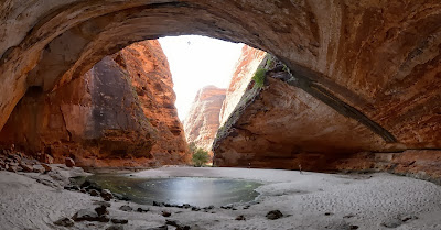
Up early the next day (5:20am) to visit Cathedral Gorge, one of the main features.  Then back on the road towards Halls Creek.


Walardi "Bush" Camp.  Wonderful! 

Cathedral Gorge.

Termite Hill.  They are everywhere.

El Questro Campground. September 25, 2013.

Wednesday, September 25th

We travelled a short distance along the "famed" Gibb River Road to the "famed" El Questro resort.  The section of the Gibb River Road was sealed, so it really does not count.  The resort is a nice campground and we decided to park ourselves for the afternoon, chill out and do some much needed clothes washing.  We spent time reading and listening to the squawks of cockatoos and other noisy aussie birds.  Extremely pretty birds but unfortunately with no beautiful accompanying bird-song.
Stephen went for a drive to Chamberlain Gorge and explored briefly up the road to Explosion Gorge.  While the gorge was nice, it was hard to enjoy it in the oppresive heat.  So a hasty retreat back to the campground was made.

To quote our guide book, "The days are warming up in September, but maximum temperatures are still reasonably comfortable".  Well, today it hit 43C (that is 109F for the Americans).  As the sun sets it was a reasonable 34C (93F).

This morning we woke up to find our fridge was not holding it's 4C temperature setting.  The assumption was that is working hard to stay cool in these hot conditions and merely draining the auxiliary battery in the process.  After the drive to El Questro, all was good again.  With some luck, nothing is actually broken, just the setup can't handle the conditions.  However, I suspected that the problem is a little more complicated with a partial failure of our split charging unit.  Further investigation is required in the next few days.  For the meantime, we might need to face the possibility of no fridge until we can work out the problem.  More to come in a future post.

Chamberlain Gorge.

El Questro Gorge at sunrise.

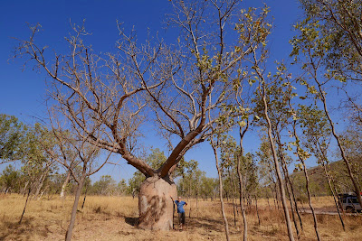
Boab Tree

Kununurra. September 24, 2013.

Tuesday, September 24th

Another hot driving day with tempertures reaching 40C outside the car.  But inside the car we measured the  temperatures at 45C under the glass.  We are not using the air conditioning system to help keep the engine temperature as low as possible as well as ensuring we do not get a shock once we get out of the car.  The overnight temperatures of 29C are the real challenge however, and humidity to also rising.  So not a dry heat.

Enough about the temperature.  We have arrived in Kununurra which is on the eastern side of The Kimberley's and also just inside Western Australia.  The drive was through open woodlands and where we saw some pretty miserable cattle.  A chat with a local at the roadhouse in Timber Creek confirmed that the hot temperatures we are experiencing are not meant to start until the end of October.  Looks like our visit to The Kimberley's is going to be hot and humid with dry waterholes and waterfalls.  Ok, it is all about the temperature.

At the campground we met a German couple who have travelled extensively in their amazing looking 4WD truck, which is totally kitted out.  They have come through the Silk Route including South East Asia, Indonesia and Timor Leste to get here to Kununarra via Darwin.  Good news, Malaysia, Thailand, Indonesia and to a lesser degree Cambodia and Laos are not a problem to get our car into.  The not so good news, Vietnam seems to be quite impossible (at the moment and according to them).

View from our roof-tp tent.

Wycliffe Well and Katherine. September 22-23, 2013.

Sunday, September 22nd

The morning was spent shopping in Alice.  We are now the proud owners of our first piece of Aboriginal Art, currently being shipped back to San Francisco.  Then headed North up the Stuart Highway.  The temperatures are soaring and the roads are long.

Wycliffe Well claims to be the "UFO capital of Australia".  We stayed the night but unfortunately did not see any green men.  The campground was wonderfully decorated in 70's style UFO paraphernalia.

Pink Galahs in the campground.

Monday, September 23rd

Up early to see Devil's Marbles.  At 8:30am it was already 31C.  The Marbles were well worth the visit.  The rest of the day was 800kms (500 miles) of wide open plains on a long straight road.  Not much to entertain us on the drive to Katherine.  The peak temperature for the day was 40C and the temperature did not start to drop until 5:30pm.  The overnight low is expected to be 24C here in Katherine.

Split Marble

Conquered Marble

Twin Marbles

Kings Canyon. September 21, 2013.

Saturday, September 21st

Up early to hike Kings Canyon. First stop however was the gas station to get a permit to "enter and transit through Haasts Bluff Pass Aborginal Land Trust along the Mereenie Loop Road between Katapata Pass and Watarrka National Park".  Or put another way, to take the back roads and short cut from Kings Canyon to Alice Springs saving several hundred kilometers of road.  With permit in hand we headed off to start our hike.

Desert Flower.
Kings Canyon hike is a 6 km track (or 4 mile) unto and around the rim of the canyon.  The estimated duration for the walk is a massive 3.5 hours.  Which seems incredible, only 1 mile an hour.  But the scenery is beautiful so it is good to be enjoyed.  And although we were on the trail at 7:45am, the temperatures were already rising rapidly.  We were in for a hot morning walk.
As advertised the scenery was quite magnificent.  Spoilt only by the hordes of other tourists.  Temperatures probably peaked at 36C.


In the afternoon we hit the dirt roads again for the trip to Alice Springs via the West McDonald Ranges or Watarrka National Park. The highlight of the park for us was Ellery Creek Hole. Imagine a waterhole in the middle of a vast and arid desert, hidden away among the rocks where people are sunbathing and swimming. The water was very cold.  But a little Oasis in an otherwise pretty harsh land.

Alice Springs greeted us with air conditioned supermarkets and shops.  Time to get some fresh meat, fruit and vegetables, which had run out about 5 days ago.  Tonight we eat well.

Yulara - Ayers Rock Resort. September 18-20, 2013.

Wednesday, September 18th

From Marla we headed north on the Stuart Highway and then turned left on the Lasseter Highway towards Uluru-Kata Tjuta NP. We both remembered lush and spacious grass fields in the campground at Ayers Rock Resort from our stay 18 years ago, so we went straight there. But for some reason or other the campground looked nothing like our memories anymore. On the contrary, it looked tired and very packed, with very little green grass. So after a drive around the other properties in the Resort we decided some luxury was called for and checked into the 'Sails in the Desert' resort hotel for 2 nights. Very nice!

Uluru and the almost full moon rising.

After doing laundry we drove to the 'Sunset over Uluru' viewing area and enjoyed the ever changing colors together with a couple of hundred other spectators. Still as wonderful as we remembered it. And yes everyone got the same photo.


Morning drive to Kata Tjuta.
Thursday, September 19th

The next morning we went for a drive around the whole area and visited Kata Tjuta (The Olgas)and the cultural center.

The afternoon was spent relaxing in the hotel, before we set out for an evening walk among (the) Kata Tjuta. We finished that just in time to catch the end of the sunset colors over the domes.

Evening walk at Kata Tjuta.

Sunset over Kata Tjuta.

Friday, September 20th

On our second morning we got up super early (at least super early for us) to start the Base Walk around Uluru before 7am. We completed the 10.6 km (or 6.5 mile) hike in just over 2 hours and before the heat of the day arrived.  This also gave us enough time to drive back to the resort and shower and relax before our 11am check-out time.  The rest of the day was spent driving to Kings Canyon Resort.  The distances between major tourist attractions in Australia are vast and everything takes time.

Oodnadatta Track: To Marla. September 17, 2013.

Tuesday, September 17th

Today we completed the last 210 kms (130 miles) of the Oodnadatta Track arriving at Marla.  The road was comparable to the previous days so we made reasonable time reaching Marla at lunchtime.  The scenery of the drive was quite different to the previous days, with the land being much greener and the trees much bigger.  The cattle looked remarkably healthy and we even spotted some wild horses that looked amazing.

The road ahead leaving Oodnadatta.

Completed the Oodnadatta Track at Marla.

Marla looks like civilization after Oodnadatta, but it is not.  Just another roadhouse. Oodnadatta had much more character in a quirky sort of way. It certainly looks like they got a good deal on pink paint!
We did not see one other car on the track that day!
Arriving early at the Marla camp-ground allowed us to de-dust Sterlin. And there was dust everywhere.  The rest of the afternoon was spent relaxing and avoiding the intense sun.

We planned the route from Alice Springs to The Kimberleys and decided to stick to the longer, but faster and safer sealed road via Katherine. Years ago we visited Uluru and we decide to take a 2 day detour to re-visit it.

Oodnadatta Track: To Oodnadatta. September 16, 2013.

Monday, September 16th

After a good night's sleep we got up for our 1hour scenic flight over Lake Eyre at 8am. There were 2 other customers and our pilot Sara. The weather was good, the wind not too much and off we went. As Kati Thanda was one of the key objectives of the Australian part of our trip, it was well worth it. We flew over Belt Bay, the actual lowest point of the Lake at -15,2m. The views were amazing. It was fun to fly over the Halligan Bay Track - you could see the corrugations from the air - that we'd driven the day before. We also got to see the campground.

Halligan Bay Track from the air.

Flying over the edge of Kati Thanda-Lake Eyre North.


At 9am were back on the runway in William Creek. As we didn't have to check out until 10am we could go and relax a little in our room before setting off towards Oodnadatta. On the way we stopped at the Algebuckina Bridge, an impressive remnant of the Old Ghan Railway.

Algebuckina Bridge.

Today's stretch of the Track was not as good as yesterday's but we still made good time and arrived at Oodnadatta around1:30pm. We checked into the Pink Roadhouse Campground. Much better weather, as in no strong winds and no rain.

Pink Roadhouse Campground Oodnadatta.

Pink Roadhouse Oodnadatta.

Oodnadatta Track: To William Creek. September 15, 2013.

Sunday, September 15th

In the morning we walked to the actual Lake to take pictures. The delevation here is -12m; the lowest point of -15.2m is in Kati Thanda-Lake Eyre North. We ventured a short distance on the salt flat only to find that there was mud soggy mud under the salt crust. In fact there was so much soggy mud that you had to keep moving your feet in order to not sink in more than 5cm/2in. At one stage Caroline tried to reposition the tripod (which was sinking in the mud a little), therefor standing in one spot for a few seconds, and when she moved one foot again promptly sank in about 15cm. While trying to recover the other foot also went under, but she managed to not fall over in the salty mud ☺. Sandals and lower legs of pants were totally caked with mud though.

At delevation -12m at Kati Thanda-Lake Eyre South.

Early sun over Kati Thanda-Lake Eyre South.


After that little adventure we continued onto William Creek to get petrol before starting on the notoriously badly corrugated dirt track to Halligan Bay.

Start of the Halligan Bay Track.


Halligan Bay has a basic campground (with toilets), but more importantly, is situated at the edge of Kati Thanda-Lake Eyre North. It took us just over 3 hours to drive the 62km Halligan Track to the end; it was (is) very heavily corrugated (*). Upon getting out of the car at the end we were inundates by flies and the wind was again very strong, getting stronger. We did go for a walk to and just on the edge of the Lake. It was, like the previous day, very muddy. Caroline here claims ‘Low Point’ number 5 (-15.2m) ! For more on this go to 7lows.com.

Beautiful sky over Kati Thanda-Lake Eyre North.


Given the weather conditions were more than likely to deteriorate to similar or worse conditions as the night before, we decided to return to William Creek for the night. Driving back Stephen tried a new technique: instead of driving over the corrugations slowly, he sped things up a tad. We’d heard that at the right speed (any speed from 35miles/50km an hour) a car kinda ‘floats’ over them, significantly reducing the shaking. And what do you know: it worked! A word of caution though: at higher speeds on dirt roads like that, anything can go wrong must faster. It is not that easy to break suddenly so one needs to be totally focused on the road. Stephen did an excellent job of it and finished the Halligan track back to the Oodnadatta Track in about 1,5 hours, getting us back to William Creek well before dark.

Corrugations on the Halligan Bay Track.

We checked into to The William Creek Hotel and enjoyed showers and a very nice pub meal. Caroline was able to wash that mud out of her travel pants.
William Creek is a tiny Outback town, located on the world’s largest cattle station, the 32,500 square kilometer Anna Creek Station (roughly the size of Belgium). The land for the hotel and associated businesses is rented from Anna Creek Station. The permanent population depends on how many people work there, anywhere between 5 and 10 at a time.

Downtown William Creek.


(*) Why is this track, which is a public access road, not regularly graded, and hence heavily corrugated, as opposed to the Oodnadatta Track? It is on the Anna Creek Station which has to grant public access on it by order of the Government, so tourists can get to the Lake. On the one hand the station’s view is: we allow access because we have to but do not feel the need to grade it. The Government on the other hand doesn’t want to grade it because it’s private land.